
Shaping Equitable Communities : How Zoning Creates Opportunity or Inequity (Part II)
Introduction
In November 2025, Richmond released the second draft map in its Code Refresh process, an initiative to “refresh” the City’s 50+ year old zoning code. The map incorporates feedback from the City’s initial round of public input on topics such as density, building height, setbacks, and zoning categories. The City has opened Draft Two for public feedback and will accept comments until February 15, 2026. As the next phase of public review begins, it’s important to consider how the proposed changes align with our climate-smart zoning priorities to build a more sustainable, affordable, and interconnected city for all.
This is the second installment in our Climate-Smart Zoning series, which explores the relationship between zoning and the environment and provides recommendations for Code Refresh. In this blog, we’ll take a look at the Draft Two map and discuss what we like, what still needs improvement, and opportunities to give feedback to the City.
What We Like
ADUs By Right
The second draft map allows accessory dwelling units (ADUs) by right across residential districts, building on the City’s ordinance that legalized the small backyard homes in 2023. ADUs, which can only be built on single-family properties, provide potential new housing units in less dense neighborhoods while making more efficient use of existing infrastructure and land. They can also benefit homeowners, who can lease the ADU to renters looking to live in those neighborhoods or house family members. ADUs are an incremental step toward increasing housing choice, but will need to be coupled with more transformative zoning and policy changes to meet the city’s overall housing needs.
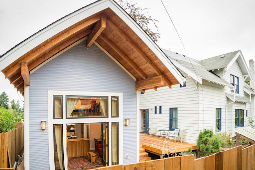
Image 1: An example of an accessory dwelling unit, in which the ADU (on left side of image) sits adjacent to the primary residence. Source: City of Tampa, Florida.
Development Nodes
The Richmond 300 plan designates certain areas in the city as Nodes, defined as “places that can accommodate additional growth in jobs and population” and/or “major activity centers today and should be preserved/enhanced.” Many of the National/Regional Nodes are along or near transit corridors. In the second draft zoning map, housing density and mixed-use development generally increase around Nodes. This strategy co-locates services, recreation, housing, and transit, helping to transform the City into a more walkable and interconnected place. Nodes encourage infill and density by reducing sprawl and focusing growth. By concentrating these services, the City can more effectively expand its transportation infrastructure to serve neighboring areas and support multi-modal streets that integrate transit, auto, bicycle, and pedestrian facilities.
What Needs Improvement
Height Restrictions
The new draft map sets new height restrictions, under which buildings cannot be more than 14 feet or one story taller than the shortest adjacent building. This means, for example, that if a building on a street is one story, then all buildings adjacent to it cannot exceed two stories. Taller or denser housing types, such as small apartment buildings, would be difficult to build unless neighboring structures are already tall enough to support more height. Considering that areas of the City with the lowest number of stories are often single-family neighborhoods, this restriction will reduce potential new units in these areas, especially missing middle housing. Missing middle/medium-density housing (pictured below) allows for multi-family properties that are still compatible in scale with single-family and transitional neighborhoods, such as triplexes, townhomes, and small apartment buildings (among others). These housing types can provide more affordable rental units and broaden the ability for people to live in areas with a high density of resources without necessarily sacrificing the character or feel of a neighborhood.
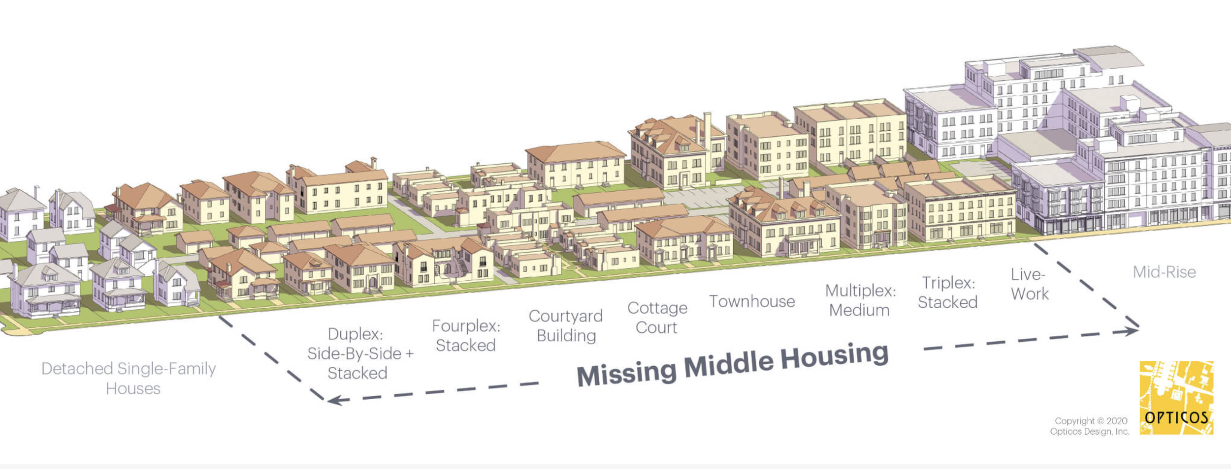
Image 2: Examples of missing middle housing types, with density increasing from left to right. Source: Missing Middle Housing and Opticos.
C3’s Ask: Increase the contextual height requirement to allow more missing middle housing options throughout the City.
Eliminating Duplexes by Right Across the City
The new draft map rolls back its previous allowance of a duplex and an ADU on all residential lots to allow for only one unit + an ADU by right in all residential districts. C3 believes that eliminating duplexes by right across the City reduces potential new housing in the City and does not meet the housing needs identified through the City’s Equitable Affordable Housing Plan and Richmond 300. It is unclear if the preservation bonus, as currently proposed, will increase the number of new units across all neighborhoods in the City, especially in wealthier areas with larger single-family homes and lot coverages.
In its Draft Two materials, the Code Refresh team explained that the decision to make this change came from concerns regarding “over-density” and “loss of character,” as well as feedback that residents “didn’t want that type of change in their neighborhood.” We support the desire of residents and the City government to preserve historic buildings and architecture. However, the City should create a more targeted preservation policy for particular areas or buildings rather than a broad blanket regulation that could continue to prevent the availability of missing middle housing across Richmond and, in some cases, still fail to preserve historic homes. The preservation bonus, for example, would not prevent landowners from demolishing a house and building a larger, more expensive single-family home (often referred to as a McMansion) in its place.
The preservation bonus was not created to prevent displacement in areas more vulnerable to development and gentrification, an issue that still needs to be addressed in the Code Refresh process. The City should consider policies that preserve low to moderate-income housing options within Code Refresh, such as a more targeted preservation bonus or a displacement overlay. They should also pursue supplementary measures to protect residents beyond the zoning code, such as the creation of a tenant relocation plan, allocating funding to programs such as the Family Crisis Fund and Eviction Diversion Program, and investing in energy efficiency and home repairs that preserve existing housing.
C3’s Ask: Allow duplexes + an ADU by right across the City. Institute targeted policies to address concerns regarding the displacement of low-income residents and historical building preservation.
Lack of Upzoning in Wealthier Areas
In the second draft zoning map, large swaths of Richmond’s wealthiest areas - including Windsor Farms, Lockgreen, Mary Mumford, Stratford Hills, Westover Hills, Three Chopt, and parts of Stony Point - continue to receive minimal increases in density compared to other areas. Stratford Hills, for example, has an RD-A (Residential Detached Low) zoning designation, which permits one single-family home with an accessory dwelling unit. One additional unit is allowed if the original house is preserved. By only allowing certain types of housing to be built in an area (in this case, largely expensive single-family homes), those who cannot afford that housing type are immediately priced out. This is particularly problematic in Richmond, where the majority of the City’s low-income residents are Black, Brown, and/or renters. These decisions pointedly limit housing choice and accessibility for certain groups. In wealthy areas such as the Museum District, many residents can only afford to live there because a few blocks of multi-unit housing are available to lease. Allowing duplexes by right is an incremental change that actively considers the existing form and character of most single-family neighborhoods while also recognizing the need for more housing units across the entire City.
C3’s Ask: Proportionally upzone wealthier, single-family neighborhoods in the City to offset development pressure in areas more vulnerable to displacement and gentrification. This should include small multi-family and missing middle housing.
C3’s Ask of YOU!
The City has released the second draft zoning map for public feedback and review. We are calling on Richmond residents to make their voices heard and support C3’s asks above. Residents are encouraged to leave comments on both the maps and the use regulations using the interactive versions, linked below. Feedback will be accepted until February 15, 2025.
Draft Two Map (Interactive)
Draft Two Zoning Regulations (Interactive)
Residents can also email written feedback and questions to richmond300@rva.gov.
To stay up-to-date on additional public engagement opportunities and events, check out our RVA zoning page!